
 Medialab-Matadero Madrid
Mostrando 2674 - 2682 de 3140
04/11/2008
Vídeo

Interactive visual analysis for the peleoceanography, which allows to go into data and control the analytic methods that take part in the reconstruction of the past climatic conditions.
04/11/2008
Vídeo
The CGI (Computer-Generated Imaginery) as a link for the architecture community. The relationship between architectural representation and digital technologies in the urban context.
04/11/2008
Vídeo
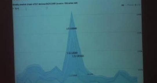
This project shows graphics about traffic speed, density and intensity in a map of Barcelona. The data are gathered from Wifi or Bluetooth in mobile phones.
04/11/2008
Vídeo
Construction and visualization strategies for the urban digital skin, adding and remixing social media and conventional sources of information. Citizen participation in the visualization of urban data.
04/11/2008
Vídeo
Studies about distributed networks for data capture and representation; its physical expressions and social implications.
04/11/2008
Vídeo
Bestiario's projects are basedon the visualization of large amount of data. Some practical ideas for the elaboration of Visualizar'08 - Database city projects.
04/11/2008
Documento

Studies about distributed networks for data capture and representation; its physical expressions and social implications.
04/11/2008
Documento
The CGI (Computer-Generated Imaginery) as a link for the architecture community. The relationship between architectural representation and digital technologies in the urban context.
04/11/2008
Documento
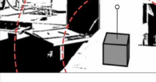
The integration of information displays in the urban environment, specially the interaction between display and environmet. The interconecction between architecture, public art and interaction design.